Fraunhofer Institute for Computer Graphics Research IGD
We supply practical and user-friendly solutions from digital agriculture for the ever more intense challenges that are arising in arable farming, grassland management and paludiculture (care of peatlands). Thes precision of resource-efficient arable farming, the efficient yet biodiversity-friendly exploitation of dynamic grassland sites and the careful management of sensitive peatland areas require individualized concepts that integrate scientific findings and innovative technologies into practical processes, thereby enhancing their sustainability. By virtue of our expertise and specialist knowledge in practical agriculture and in digital technologies derived from AI-supported close-range and remote sensing, we are able to provide tools for arable and grassland farming that address and meet the current challenges of the agricultural sector.
Crop
Solutions
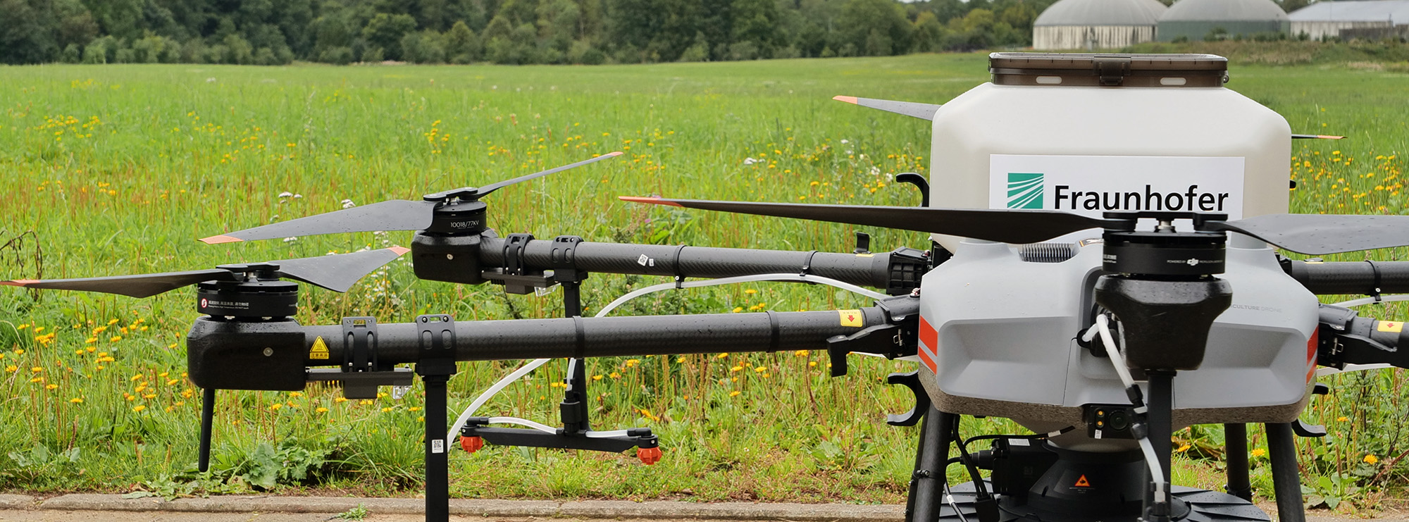
In tackling the complex challenges and areas for development in the arable and grassland sector, we use innovative graphical data processing supported by machine learning and AI algorithms, thereby designing solution strategies for smart and precision farming. Satellite-, drone- or robot-based imaging methods allow the collection of wide-ranging, information-rich (and thus valuable) data on plant populations. We use RGB, multispectral/hyperspectral cameras and LiDAR sensors, which provide insights and solutions for the optimization of arable and grassland management.
- Biodiversity monitoring: Complex species compositions or the identification and localization of certain characteristic species require the use of both high-resolution and multi- and hyperspectral imaging methods, especially in the grassland sector. The results serve as a data-rich basis for training neural networks. For example, drone images can be used to generate maps showing the species composition in a particular area of grassland, which can then be used as evidence of a species-rich expanse of grassland or a potential nature reserve.
- Grassland management: Determination of optimal cutting time and the sustainable and efficient management of meadows and pastures are major challenges in grassland management that can be supported by camera and laser-based close-range and remote sensing. The determination of species composition and the digital analysis of vegetation biomass are both valuable parameters that can be derived from drone image data by means of machine learning methods.
- Crop development: Drone and satellite-based remote sensing makes it possible to monitor arable and grassland crops with regard to plant and biomass development, as well as nutrient supply and yield estimates. This data can be used to create fertilizer application maps as well as yield maps.
- Quality breeding: Drone and robot-based camera systems allow high-resolution 2D and 3D imaging processes to provide information with millimeter precision on plant development, height, leaf area, flowering times, biomass and much more besides. The use of these parameters at a high frequency can be automated, thereby generating valuable data sets for rating and variety evaluation.
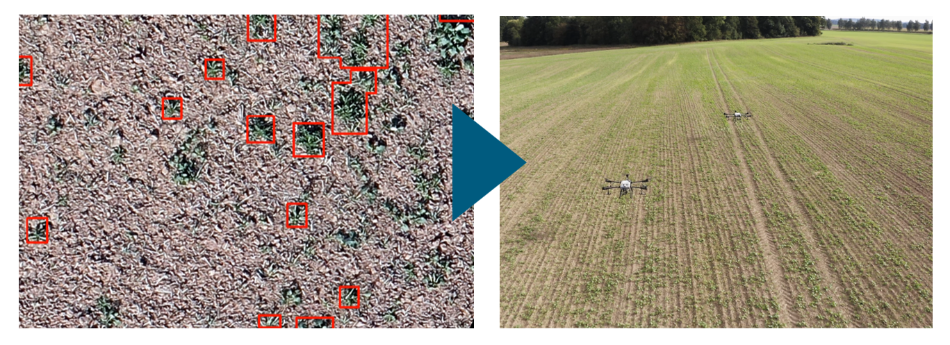
- Plant protection: Innovative camera technology using multispectral and hyperspectral imaging is an essential tool in arable and specialty crops for detecting the presence of weeds, disease and plant stress at an early stage. Spectral analyses can be undertaken to detect various diseases and types of plant stress, and weeds can be identified and localized so that precise plant protection measures can be taken for cultivation that is both economically and ecologically sustainable.
- Peatland monitoring: Multimodal analysis – the combination of physical sensor technology and optical imaging – facilitates the monitoring of peatlands with regard to their ecological stability and development potential. The interaction of different technologies allows the mapping of the complex relationships between vegetation and biodiversity development, soil and (greenhouse) gas balance, all of which is essential for the valorization of ecosystem services.
- Harvest quality: Hyperspectral cameras (i.e. spectrally high-resolution systems) provide an insight into the ripening processes and chemical constituents of fruit not only in the field or on the plantation but also in storage and processing facilities after harvesting. This means that the determination of fruit and harvest quality using innovative camera technology can function as a decision-making aid or for analyzing the quality of produce even before it is harvested.
Our AI-based solutions utilizing high-resolution camera and sensor data provide detailed insights into the complex environmental, physiological and structural relationships and the dynamics of arable and grassland farming. The optimized interaction of automated technologies and intelligent algorithms supports management decisions, efficiency improvement and sustainability strategies and thus contributes to future-proof, modern and digital precision agriculture.
Typical application: Biodiversity determination
From image material collected by drone overflights, an AI-supported algorithm recognizes and localizes the species composition of herbaceous vegetation in grassland and arable land and/or certain species of forage plants or weeds. Image data is gathered over several years at different locations and times using drone-mounted RGB and multispectral cameras. The data is initially used for training of the algorithm and in subsequent years for its ongoing learning. In this way, species recognition algorithms can be continuously improved and made more precise with ever larger and more specific data input.
For practical situations, software and online solutions are being developed that can be used to apply specific or general recognition algorithms to the drone data and provide the results in information or spray application card format. These serve not only as a decision-making aid and as evidence for the relevant authorities, but also as map material for direct use by agricultural machinery or by agricultural drones in precision agriculture.